Hiking Four Mile and Panorama Trails
Glacier Point offers one of the “must-see” views in Yosemite National Park and is generally reached by commuting up a narrow, winding road of switchbacks, but it is possible to avoid that road entirely if one takes advantage of the hiking trails that lead to the popular destination. One of the oldest and most well-known trails that connect Glacier Point with the valley floor is Four Mile Trail, a set of switchbacks that almost directly climbs the glacier-carved cliff face. This trail has been on my bucket list since I was in high school, so of course, it made it onto my Yosemite itinerary as an activity that would only be omitted if the trail were closed because of unforeseen circumstances.

The first view from Four Mile Trail.
Four Mile Trail is one of the historic trails that first served as a toll trail beginning in 1872 as one of the few easily traversable ways to access Yosemite Valley and Glacier Point. Over the years, the trail has changed and is now closer to five miles one way than the initial four miles when it was originally cut into the side of the mountain (plus the toll has been removed). The length of this trail makes it seem more moderate than its actual rating, but the elevation gain and steep grade of those miles, Upper Yosemite Falls was only 7.2 miles round trip. Unlike the Upper Falls Trail, Four Mile is almost entirely shaded both by vegetation and the actual cliff that the trail climbs for the first half of the day. This shade provided much-needed protection from overheating when my partner and I tackled the trail and we remained comfortable while we hiked on the warm late June day.
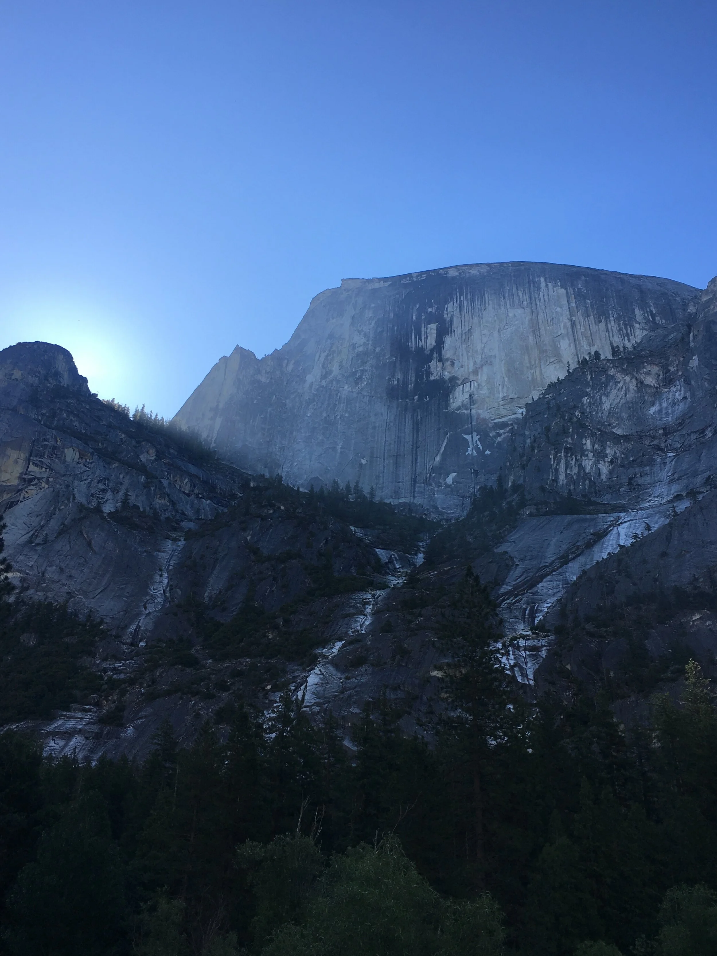
Like any other day during our Yosemite trip, my partner and I rose before dawn and aimed to be at the trailhead at or shortly after sunrise (maximize the daylight!). We parked near Swinging Bridge and walked the short distance to the trailhead instead of utilizing the barely-there street parking designated for Four Mile Trail. The morning was crisp, birds were just starting to sing as the sun peeked into Yosemite Valley over the surrounding mountains, and our muscles had recovered from our trek up to the top of Yosemite falls just a couple of days prior. To be honest, I was terrified of this trail after having underestimated the overall difficulty of the Upper Falls Trail, and I was not certain that I would be able to make up the 3,200ft to Glacier Point. I had barely convinced my body to carry me up 2,700ft, nevermind that that trail was much steeper than the one I was beginning that morning, but I knew that I would not forgive myself if I did not at least try to complete the journey.

Yosemite Falls from Four Mile Trail
After about an hour, we were pleased to find that the trail was not as terrifying as we had both privately worried it would be and the slope was very gentle compared to our introduction hike two days prior. When we stopped for our first snack break my partner and I admitted to one another that we both had the same worries about our own personal ability to hike Four Mile Trail when we embarked in the morning, but the distance we had already covered squashed those fears. When we set off once again, we had a new spring in our step and were able to appreciate stunning views that the trail offered. We stopped often to gaze out at the sights and snap a few photos that are unable to truly capture the majesty of the moment, but they do envoke the emotions that I felt during that day.
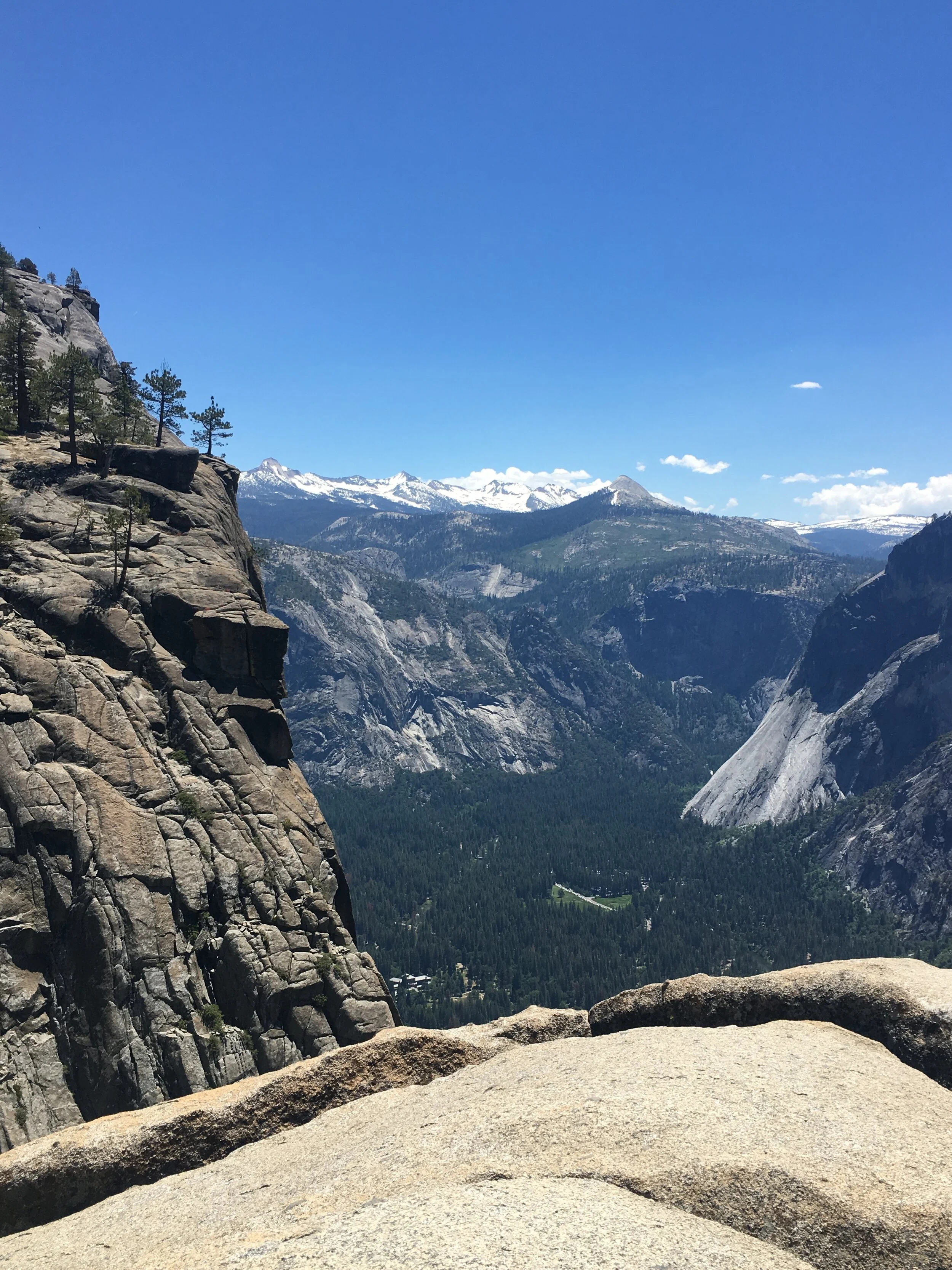
The distant roar of Yosemite Falls was a constant companion the entire way up the trail, and we were rewarded with a unique view through the trees of the very falls that call to every Yosemite visitor once the snow begins to melt far above in the high country. On the trail, hikers can glimpse both the Upper and Lower Yosemite falls, plus the mysterious midsection between them where water violently churns from one free fall to the next. Four Mile Trail is the only way to easily take in this sight, and we were lucky that the falls still flowed with a volume usually seen only by those who make it to the valley in the spring. The rest of the hike was no less breathtaking with its views of El Capitan near the start, and Half Dome near the end of the trail. We chose to make the short detour to Union Point (about two-thirds of the way up) where we gazed out over the valley and out at the previously absent Half Dome.

View from Union Point.
With a new determination, we left Union Point and continued up the trail and reached Glacier Point slightly ahead of schedule. We found a bench in the shade where we could take in the view while we ate our lunch (leftover gumbo from the night before) and reflected on the distance we had just covered. Once our bellies were full, we took our time to explore Glacier Point and glimpse the switchbacks that we had just climbed. It was a bit dizzying to look down on the path I had just traveled, but I felt both accomplished and amazed that I had started at the valley floor and traveled up the side of the cliff entirely on foot. Of course, getting to the top was only half the journey, because we had to make it back down to the valley to return to the car and head back to camp. With a little reluctance, we refilled our water and headed for the Panorama Trail to begin our descent.
Panorama Trail was fairly easy to travel since it has a much more gentle slope than Four Mile Trail, but is almost twice the distance and lacks shade for most of the journey. Despite the lack of shade, it was easy to remain cool thanks to the seasonal creeks that constantly crossed our path and our constant stops to admire the trail’s namesake view.

The view from Panorama Trail.
Panorama trail eventually joined the John Muir Trail, and at the top of Nevada Falls, we had to decide how to make our final descent back to the valley below. We had to either continue on the John Muir Trail or turn off and take the Mist Trail, we chose the Mist Trail because some slow hikers we had been stuck behind for a couple of miles that refused to yield and allow us to pass chose to continue on the current path. In retrospect, we should have traveled down the John Muir Trail. The staircase next to Vernal Fall was treacherous because of the spray and we were thoroughly soaked by the freezing water by the time we finally made our way off the stairs, I do not recommend descending this way when the water is that high if it can be avoided. The staircase was the most exhausting leg of the journey, and I was glad to return to camp and dry clothes that night.